Hallasan: trails, summit access and planning
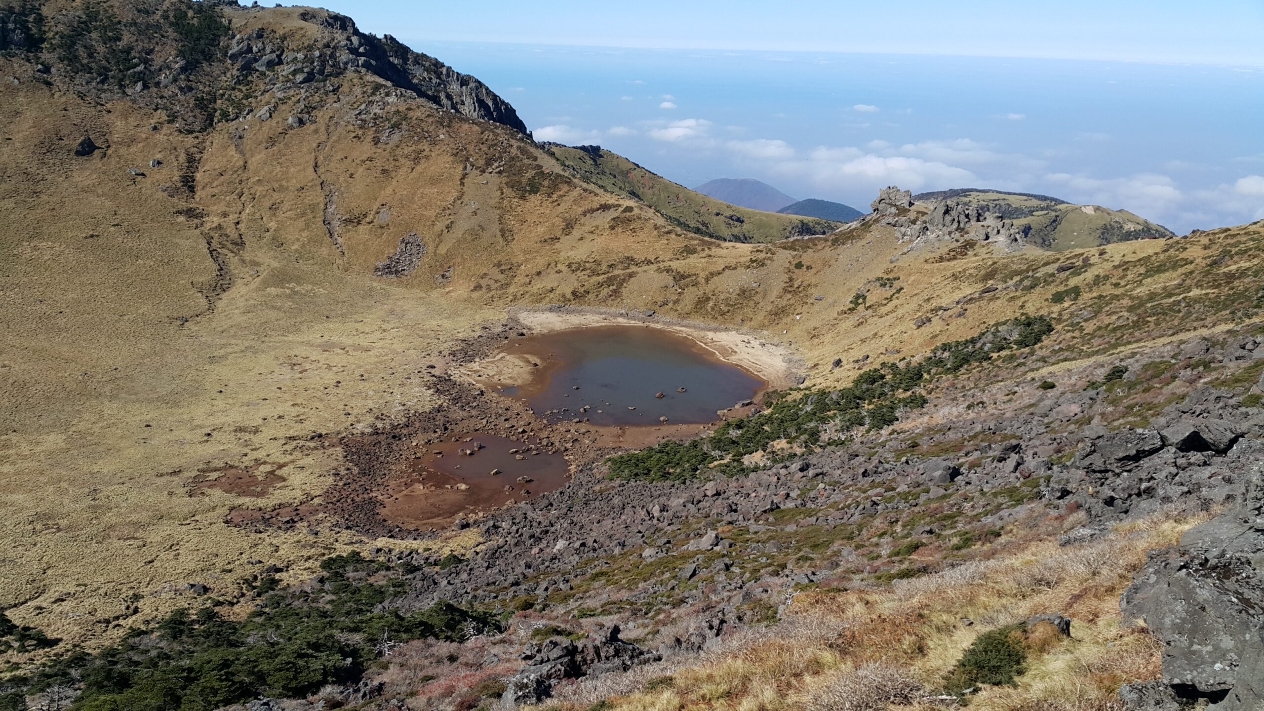
The Peak of Hallasan, Baengnokdam 1.jpg by Joshua0608, CC BY-SA 4.0.

Hallasan stands at the centre of Jeju Island, South Korea. Visit Jeju gives the mountain an elevation of 1,950 metres and describes it as South Korea’s highest mountain. In UNESCO’s wording, Mount Halla is one component of the serial property Jeju Volcanic Island and Lava Tubes, inscribed in 2007. That inscription does not make the whole island the World Heritage property.
This page is for choosing a trail and understanding access. Food, coast, and where to stay are covered in the Jeju guide.
The park and its designations
Hallasan National Park’s history records national-park designation in 1970 and natural-reserve designation in 1966. Separately, UNESCO describes alpine forests at Mount Hallasan within Jeju’s volcanic geopark landscape. That geopark description is not the same designation as the 2007 World Heritage inscription.
The seven trails
The park index lists Eorimok, Yeongsil, Seongpanak, Gwaneumsa, Donnaeko, Eoseungsaengak, and Seokguram. They do not share one endpoint.
The park limits summit access to Seongpanak and Gwaneumsa. Those two routes are described as running to Baengnokdam. The designation does not mean either trail is open on a given day. Current section closures still have to be checked, and this page does not suggest a way around a closure.
The other five trails are not Baengnokdam routes. Eoseungsaengak reaches that peak’s own summit, not Hallasan’s Baengnokdam summit. Seokguram, on Jeju, ends at Seokguram hermitage.
Distances below are one way, from the start named in the park’s route page. Where a time is shown, it is the park’s published figure, not a prediction for a particular group. For Seongpanak, Yeongsil, and Donnaeko, the park’s own pages do not agree on one duration, so no duration is given.
| Trail | Start | Endpoint | Distance, one way | Park duration | Summit access | Summit reservation |
|---|---|---|---|---|---|---|
| Seongpanak | Seongpanak management office | Baengnokdam / Dongneung summit | 9.6 km | Not shown; official sources disagree | Designated, subject to current controls | Upper section only |
| Gwaneumsa | Gwaneumsa district campground | Baengnokdam / Dongneung summit | 8.7 km | About 5 hours | Designated, subject to current controls | Upper section only |
| Yeongsil | Yeongsil rest area | Nambyeok Junction via Witse Oreum | 5.8 km | Not shown; official sources disagree | No | Outside the summit reservation |
| Eorimok | Eorimok trail entrance | Nambyeok Junction via Witse Oreum | 6.8 km | About 3 hours | No | Outside the summit reservation |
| Donnaeko | Donnaeko information centre | Nambyeok Junction | 7 km | Not shown; official sources disagree | No | Outside the summit reservation |
| Eoseungsaengak | Beside the Eorimok visitor centre | Eoseungsaengak summit | 1.3 km | About 30 minutes | No | Outside the summit reservation |
| Seokguram | National Jeju Memorial Cemetery parking area | Seokguram hermitage on Jeju | 1.5 km | About 50 minutes | No | Outside the summit reservation |
Two intermediate points matter for the reservation line later. On Seongpanak, Jindallaebat is listed at 7.3 km. On Gwaneumsa, Samgakbong is listed at 6 km.
Yeongsil’s 5.8 km figure is the rest-area route. A separate 2.5 km approach connects the Yeongsil management office and the rest area. That approach is not part of the 5.8 km trail, and the 5.8 km figure is not a distance from a bus stop. Donnaeko’s 7 km route runs from the information centre via Pyeonggwe shelter.
Summit reservations
The official reservation system is operated by the Jeju Special Self-Governing Province Hallasan National Park Management Office. Confirm the current rule for your date on that system. This page does not sell or reserve a place.
A park adjustment notice applies reservations to Jindallaebat–Baengnokdam on Seongpanak and to Samgakbong–Baengnokdam on Gwaneumsa. The same notice permits unreserved access as far as Jindallaebat on Seongpanak and Samgakbong on Gwaneumsa, subject to controls. Unreserved access in that notice stops at those points. It is not permission to pass the upper checkpoints, and it does not set visiting hours.
Eorimok, Yeongsil, Donnaeko, Seokguram, and Eoseungsaengak are outside the summit reservation requirement. That does not make them unrestricted. The notice still leaves them subject to trail, time, and weather restrictions.
The operator warns that opening-day queues can end after dates are fully reserved, and that the availability page may be temporarily hidden. This page does not report which dates are open, and it does not give a reservation opening time.
The public login page directs foreigners who cannot use real-name verification to email verification on a foreign-language page. That direction was read from the page. Completing a reservation was not tested, and the page does not establish which phone formats the form accepts.
The English operator notice requires each visitor’s QR code and identification, including a passport, and says QR codes are sent by email. Check that instruction again before you travel. It can change.
Weather controls and winter guidance
A dated park notice permits restrictions for adverse weather, including severe wind, snow, rain, fog, and identification of an unsafe trail. A reservation does not override a closure. This page does not include a forecast.
The park warns of rapidly changing weather and fog, and it advises preparation for wind, rain, and snow. Its winter guidance names warm clothing, crampons, gloves, warm water, and a light. Those are named recommendations, not a statement that each item is a legal requirement.
Park guidance requires the designated trails and tells visitors to check seasonal control times. The clock times themselves are not repeated here, because they change and were kept out of this draft.
On the Seongpanak route page, the park warns that shorter winter daylight increases descent risk and urges visitors to finish before darkness. That is a daylight warning for that route. It is not a ranking of seasons.
For Korea’s broader seasonal climate, not for Hallasan’s operating rules, see when to visit Korea.
Trailhead access
Published bus listings below are orientation only. They are not frequencies, journey times, or a statement that every departure still runs. Recheck the operator timetable for your date.
The transport authority’s 281 northbound timetable includes Seongpanak between the Seogwipo and Jeju bus terminals. That listing does not cover every direction, and it does not give a ride time.
The published 475 loop lists Jeju University and the Gwaneumsa trail entrance. The published 240 southbound route lists the Eorimok entrance, the Yeongsil entrance, and the Yeongsil branch office. A stop on that list does not establish the walk from the stop, and it does not mean every departure serves it.
The park warns that Seongpanak parking is limited and that visitors may not find a space. It recommends public transport. That is not a count of spaces, and it is not a claim that a car is required.
The park gives separate trailhead addresses: Seongpanak at 1865, 516-ro, Jocheon-eup, Jeju-si, and Gwaneumsa at 588, Sanrokbuk-ro, Jeju-si. Do not treat one address as the start for every trail.
Facilities, water, and park rules
The lists below are facilities the park names on its route pages. Naming a shelter, toilet, or spring is not a statement that it is open, staffed, or supplied on the day you go.
On Eorimok, the park lists the Witse Oreum shelter and toilets at Eorimok plaza and Witse Oreum. It also notes that Saje-bi spring can dry in dry periods. On Yeongsil, it lists toilets at the management office, the rest area, and Witse Oreum, plus the Witse Oreum shelter, and notes that Noru spring can dry.
On Donnaeko, the park lists Pyeonggwe shelter and toilets at the information centre and the shelter, and it warns that the route has no spring water. On Seongpanak, it lists Sokbat and Jindallaebat shelters, with toilets at the office and those shelters. On Gwaneumsa, it lists Samgakbong shelter, with toilets at the campground, Tamna Valley, and Samgakbong.
The operator’s English notice warns visitors to prepare food, water, and equipment in advance because there are no stores on the mountain. Read that as preparation guidance, not as a live inventory of services at a trailhead. The park also advises carrying sufficient drinking water, because water is not readily obtainable on the mountain.
The park instructs visitors to report an emergency to its office or to 119, and to give the number on a nearby trail-location sign. That instruction does not describe medical treatment or how long a rescue will take.
Park rules prohibit taking plants, insects, or stones, and ask visitors to take rubbish away. Safety rules prohibit drinking alcohol and smoking. Camping and cooking are limited to the Gwaneumsa district campground. That limit is not a vacancy notice, and this page does not link to a campsite. Those rules are the park’s published instructions. Confirm the current notice before you go.
The park’s official centre page describes exhibition and video spaces covering Hallasan’s heritage and ecology. The centre listing includes an information desk, a video room, an exhibition room, and a rest space. Opening hours for the centre are not included.
Checks before the day
Use the park’s own notices for the date you plan to go. The checks that follow are the ones this research could support:
- Confirm the trail, and whether summit access is even designated for it. Designation is not the same as an open trail.
- If the plan goes above Jindallaebat or Samgakbong, confirm the reservation section and whether your date is still available. A full opening-day queue, or a hidden availability page, is a reason to look again rather than assume a place.
- Read the current weather restriction and the seasonal control times. Do not treat a reservation as permission to enter a closed section.
- Recheck the published bus listing for the trailhead you will use, including whether that stop is still served.
Elsewhere on Jeju
Hallasan is the mountain at the centre of the island, and the trail choice is only one part of a Jeju trip. Continue with the Jeju guide or the wider destinations index.